Donkeys, Flamingos and Mountain Trails
A short drive from town, in the direction of Malaga, is the small town of Fuente de Piedra … best known for its lake – Laguna – where each year tens of thousands of flamingos come to nest.
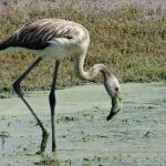
https://andaluciainmypocket.com/fuente-de-piedra-where-to-see-pink-flamingos-in-spain/ These Greater Flamingos don’t turn entirely pink (like those in the Caribbean – or lawn ornaments) however their white, pink and black plumage is striking and beautiful. Normally, by this late in the season, the flocks (a flamboyance!) would have flown south to Africa but as this is the largest natural lagoon in Spain, and an important migratory stop-over for other birds, we took a chance there’d be other birds to see. In the Spring and Fall, rain fills this flat, marshy area into an enormous (but shallow) semi-salt lake, however after this summer’s never-ending series of heatwaves, the lake bed was completely arid and bleached. The marshy area along the main drive still contained brackish-looking water rimmed with a layer of green algae, reeds and scrubby trees. A thin strip of water was visible in the distance – so perhaps a bit deeper? Wait … was that …? “Quick … Stop The Car. Look!” And there, calmly feeding in the murky water right beside the driveway, were THREE flamingos. Not flamboyant, I’ll grant you, but we’ll take them. Leaning against a handy fence, we watched as they slowly paced on their long legs, huge curved beaks upended in the water … filtering the tiny crustaceans that sustain them. Quite magical.
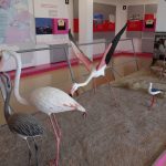
At the Visitor’s Centre … not exactly brimming over with visitors, as you can imagine (two guides were sitting on the shaded front steps, chatting to a delivery driver) … however there was an excellent presentation of information, models, photos … and one wall entirely of glass, overlooking the lagoon. To see the lake covered with these majestic birds would be an experience indeed.
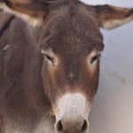
Just down the road is a Donkey Sanctuary – El Refugio del Burritos. Connected to the UK charity for rescuing injured and abused Burros – it houses around a 100 individuals. Disappointingly, the facility is closed temporarily – although a couple of burros peered sleepily at us though half-closed eyes. Perhaps the refuge will reopen before we leave. This video on YouTube (although all in Spanish) gives you an idea of the area around Antequera. https://www.youtube.com/user/elrefugiovideos
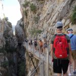
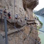
One of the must do excursions while in Antequera is the Caminito del Rey – the King’s Little Walk. https:///en/hiking-trails/caminito-del-rey-hiking-in-spain/
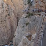
Once known as one of the most dangerous walks in the world, with its narrow, crumbling paths barely clinging to sheer rock walls – parts of it missing completely, and giving full view of the Guadalhorce river thundering through a chasm 100 meters below. There are horrifying videos on youtube of people doing just that, and after several fatalities, it was closed.
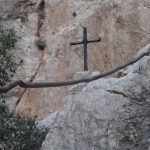
The original project started in the early 1900s so that workers and supplies could be brought in to maintain the dam, it was officially opened in 1921 by King Alfonso. It’s hard to believe that in the original construction, only two workers lost their lives … and one of those through carelessness – he took a smoke break beside some explosives! Families lived in the area right up until the 1970s, and children would daily walk the path into El Chorro to attend school. The walkway fell into disrepair and over the years, some 600 people have succumbed … the last in 2000 when a group of friends (after a night of considerable drinking) decided to use one of the steel cables crossing the gorge as a zipline … 3 at the same time. It couldn’t support their weight. Only the one with vertigo, who had refused the challenge, survived to notify authorities. There’s a metal cross on the wall above. Local government planned to dynamite and seal both ends of the Caminita trail, but it was deemed too important a landmark. Restoration finally took place, and it was reopened to the public in 2015. Must admit it was reassuring to see that every single fixture, cable and fastener was made from stainless steel – even the mesh fencing.
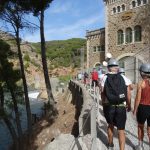
In total, the trail is 7.7 kms long, one way — so you can either park at the beginning and take the shuttle bus back when finished, or the reverse. Fortunately we had left a comfortable time margin, as signage was not the best, and parking at the beginning (village of Aldares) was filled to overflowing. In El Chorro – the other end, we found a large, tree-covered parking area just a few minutes hike from the train station and the shuttle bus. Masks on. The seven kilometer drive winds through hillsides of bright green pine and soaring rocky outcrops – each cleft and ledge sharply outlined in the sunlight. At one point our bus met a returning one (and these are coach-sized, not small). The other bus slowly backed down to a fractionally wider spot, and they passed with centimeters to spare. The drivers could have reached out and shaken hands! Earlier, as we left town, two cars thought they could cut off the bus and squeeze ahead – the driver was having none of that, and forced them to retreat, to the glee of us passengers.
In we went, through an opening in the wall and a darkened tunnel lit with subdued footlights. A burst of sunlight, and a very pleasant 1.5 km stroll along the tree-lined river to the ticket gates. Our meeting time was 3:30 for the guided tour at 4:00 so there was a flurry of people sorting themselves out with snatches of German, Dutch, French, Arabic, English, and Spanish. Of course there was a line up for facilities, but fortunately these baños were dual use. And then there were the flies – clouds of them … annoying, incessant … despite the constant swatting and flapping. They landed on you everywhere like a black-spotted pox!
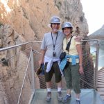
We were herded … sorry, gathered into groups of preferred language, issued with chic single-use ‘hairnets’ and hardhats – each group a different colour (ours was grey). . . and listening devices to follow along with the guide. Ours was called Robert (probably Roberto). Humour doesn’t always translate well from one language to another, but he did well. And off we set.
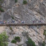
The way was shaded by the canyon sides and you couldn’t have asked for a more perfect temperature. Wooden boardwalks, a tumbling, rushing river – which at present we are only 30 meters above … the mountain tops glowing red and gold. A careful peek over the edge. Don’t fall in! Way above, soaring on the rising thermals were the Griffin Vultures . . . each with a two and three-quarter meter wingspan … just waiting. That’s one kilometer done.
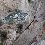
The second stage was through a wooded, boulder-strewn hillside, beside – and sometimes IN – the defunct water channels. We spotted several shy mountain goats foraging and blending into the undergrowth. A derelict casa where a family with ELEVEN children once lived … they had a swimming pool, fruit trees and even a space for helicopters to land – should there be an emergency. A red and white windsock still flies there.
Robert would periodically test the group’s knowledge (e.g. plants and their uses) but at one point asked how many workers had died in constructing the walkway. He pointed to individuals, and received answers anywhere from 0 to 600 … smiling a little as none gave the correct answer. Then he pointed to Glen … “Two”. I’m sure I saw a brief glimmer of disappointment cross his face, but Glen owned up to having recently read about it online. There were Carob trees here – with their long brown distinctive pods. Robert rattled off the word for Carob in what must have been 15 languages … including Polish!
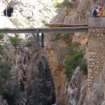
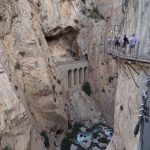
Third stage. We are now 100 meters above the river. The pathway curls and winds its way around the sheer cliff faces … closely hugging the rock … sometimes it’s barely a couple of feet wide. You can see portions of the original path directly below and how it was only supported by wooden beams. A touch windier up here, but certainly not concerning. On really windy or wet days there is a tunnel through this section.
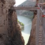
Everyone had their photo taken on ‘The Crystal Deck’ – a section of plexiglass floor projecting out over the precipice. Thankfully, not too scary (probably because you could hardly see through it!) After that was ‘The Hanging Bridge’. Open metal grid decking, spanning the gorge and giving a view of the drop below. There was a definite sense of movement up and down and a slight swaying side to side. Hmm. The only time throughout the whole trail where I felt a little unease. The remaining 1.5 kilometers was via more clinging walkways with spectacular views over the old railway lines and dam as we gradually descended into the town and through an avenue of huge, peeling Eucalyptus trees. All-in-all today we probably walked around 8.5 – 9 kilometers … and what a fantastic experience.
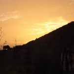
On the drive back – adamantly defying all of Miss Google’s protestations to re-route us – we discovered the old road to Antequera. Ever climbing and narrowing, it wended its way first through olive groves, then open fields with views across inter-connecting valleys in a patchwork of brown, red and gold, interspersed with Olive and Orange plantations. Old farm houses dotted the hillsides – glinting in the evening rays.
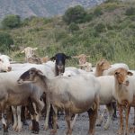
Around one corner – a flock of sheep smothered the road, while the old shepherd, relying on two sticks for support, rounded up the stragglers, who were busily munching their way through the undergrowth. We waved that there was no hurry . . . and I happily took dozens of photos. Further along, the remainder of the flock stood their ground in the middle of the road, their guardian – a big black and white sheepdog – looking on.
These guys were not going to budge – staring stubbornly and baaa-ing – bells clonking all the while. As the shepherd was not in sight, I gently shooed them to one side so Glen could ease past, stepping cautiously through the carpet of sheep droppings.
The clouds behind us turned from pale lemon to gold to pink as the sun slowly sank – in front, an almost full moon rose over the mountains. Definitely a photo opportunity.
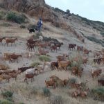
Suddenly a herd of brown and white goats materialized, grazing their way down the hillside beside us … the goatherd and his dog moving them slowly onwards. THIS is the old Spain – traditional … earthy … unchanged. One has to pinch oneself!
Ah, but wait, what’s this? … for there in the midst of an olive grove – a solitary solar panel. A nod to modern technology!
4 Comments
Kay
Your mountain trail reminded me of Meteora in Greece – white knuckle monolithic mountains. Monks were hauled to the top in bags.
-so enjoying your blog – has to take quite a bit of time to write. Thank you!
Jennifer Smith
I’ve seen pictures — no thank you! I’ll stick to the Caminito if you don’t mind
Posts are done in bits and pieces. Jot down notes as we drive (so I don’t forget!) and then whenever there’s a few minutes I’ll work on the blog. Glad you’re enjoying the journey.
Tim
Great descriptions….. The reader Just needs the full sensory experience of goat and sheep droppings. (But surely Fuente de Piedra and its Laguna is north-east of Antequiera?)
And in an earlier comment I mentioned Bocadillo being a strange name – perhaps I mis-read Bobadillo – which is a real place. Do you get high quality olive oil served for dipping bread in a restaurant? So much excellent olive oil comes from that region.
Jennifer Smith
Yes … A slip up. I HAD meant to say you initially take the Malaga road at the roundabout, then turn off to Fuente . . . where’s my editor in chief when you want him?
He did also pick up on the typo Bocadilla/Bobadilla (now corrected) – his with a smart-arsed comment though!
The olives and oil are wonderful . . . several producers locally.